Abstract
This study assessed seasonal variation, spatial distribution, and screening-level health risks associated with PM2.5, Benzene (C₆H₆), and SO₂ in the Phu Tai Industrial Zone (IZ), Binh Dinh Province, Vietnam. A total of 120 samples for each pollutant were collected during summer (June–July 2023) and winter (December 2023–January 2024) at four representative boundary sites, with sampling conducted during both daytime and nighttime.
To address methodological limitations identified in previous studies, this research applied detailed quality assurance and quality control (QA/QC) procedures, statistical testing (t-test with a 95% confidence interval), uncertainty analysis, and a clearly defined qualitative ecological risk assessment framework.
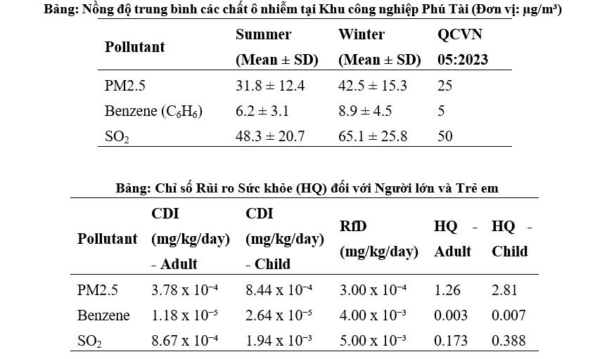
The results showed that the average concentrations of all pollutants exceeded the permissible limits specified in QCVN 05:2023/BTNMT. PM2.5 was identified as the dominant pollutant, with significantly higher concentrations in winter (42.5 ± 15.3 µg/m³) than in summer (31.8 ± 12.4 µg/m³) (p < 0.05). A similar seasonal variation was observed for SO₂.
The use of an RfD-based Hazard Quotient (HQ) for PM2.5 is interpreted strictly as a screening-level indicator, acknowledging that concentration–response epidemiological approaches are more commonly applied for quantitative risk assessment of fine particulate matter.
The findings provide scientific evidence to support air pollution control strategies and public health protection measures in industrial–residential interface areas.
Keywords: PM2.5, Benzene, SO₂, health risk, ecological risk, Phu Tai Industrial Zone
1. Introduction
Air pollution, particularly fine particulate matter (PM2.5) and toxic gases such as Benzene and SO₂, is a serious global issue that adversely affects human health and ecosystems [1]. In Vietnam, industrial zones (IZs) are among the major sources of these pollutants due to industrial production activities, transportation, and fossil fuel combustion [2].
Phu Tai Industrial Zone, located in Binh Dinh Province, is an important industrial area in Central Vietnam, with a large scale and diverse range of industries, including wood processing, mechanical assembly, construction materials manufacturing, and textile production. The industrial zone is situated within a complex geographical setting: it is bordered to the north by the Ha Thanh River and residential areas; to the south by residential areas and the road leading to Long My Industrial Zone; to the east by National Highway 1A and residential areas; and to the west by Hon Cha Mountain. This geographical configuration creates a relatively enclosed environment that may limit the dispersion of pollutants while potentially increasing health risks for surrounding communities and risks to the natural ecosystems associated with the river and mountainous areas.
Although numerous studies have assessed air quality in industrial zones across Asia, there remains a lack of site-specific data for medium-sized industrial zones in Central Vietnam that simultaneously integrate seasonal monitoring, screening-level health risk assessment, uncertainty analysis, and receptor-based ecological risk assessment. This study therefore aims to provide a transparent methodological framework and baseline dataset applicable to similar industrial transition areas.
Accordingly, the objectives of this study were to: (1) determine the concentrations and spatiotemporal variations of PM2.5, Benzene, and SO₂; (2) analyze correlations among the pollutants; (3) assess potential health risks to surrounding communities; and (4) evaluate ecological risks based on the specific landscape characteristics of the study area.
2. Materials and Methods
2.1. Study Area and Sampling Design
The study area comprised Phu Tai Industrial Zone and its surrounding areas. Sampling sites were established at four representative locations corresponding to the four surrounding directions:
PT-N: Northern boundary, near the Ha Thanh River and residential areas.
PT-E: Eastern boundary, near National Highway 1A and residential areas.
PT-W: Western boundary, at the foot of Hon Cha Mountain.
PT-S: Southern boundary, near residential areas and the road leading to Long My Industrial Zone.
Air samples were collected over 60 consecutive days for each season: summer (June–July 2023) and winter (December 2023–January 2024), with two sampling periods per day: daytime (9:00 a.m.–3:00 p.m.) and nighttime (9:00 p.m.–3:00 a.m.).
A total of 120 samples were collected for each pollutant. Each sampling site contributed 30 samples per season.
3. Results
The QA/QC assessment confirmed that all analytical procedures met the predefined performance criteria. Blank contamination was negligible, the accuracy of duplicate samples remained within acceptable limits (RPD < 10%), and calibration stability was verified on a daily basis.
An uncertainty range of ±8–12% was incorporated into the interpretation of seasonal comparisons and HQ calculations. Sensitivity analyses showed that variations in uncertainty did not change the overall risk classification. For example, the HQ for PM2.5 remained greater than 1 for both adults and children, even under the lowest-concentration scenarios.
These findings further support the robustness of the observed seasonal and spatial variation patterns.
The health risk assessment results (Table 2) showed that, for adults, the Hazard Quotient (HQ) for PM2.5 was 1.26 (>1), indicating a potential risk of adverse health effects associated with long-term exposure to the current PM2.5 concentrations in Phu Tai Industrial Zone.
However, the most concerning result was observed among children. With an HQ of up to 2.81, children living in the area face a substantially higher potential health risk than adults. This is attributed to their higher breathing rate relative to body weight, as well as their still-developing respiratory and immune systems, making children particularly vulnerable to fine particulate matter pollution.
Meanwhile, the HQ values for Benzene and SO₂ were both below 1, indicating that their estimated risk levels were within the acceptable screening range.
References
[1] WHO, 2021. WHO Global Air Quality Guidelines: Particulate Matter (PM2.5 and PM10), Ozone, Nitrogen Dioxide, Sulfur Dioxide and Carbon Monoxide.
[2] Lai Nguyen Huy and Nguyen Thi Kim Oanh, 2021. Development of Attested and Readily Publicised Air Pollution Emission Inventories Database for Southeast Asia.
[3] US EPA, 2009. Risk Assessment Guidance for Superfund Volume I: Human Health Evaluation Manual (Part F, Supplemental Guidance for Inhalation Risk Assessment).
[4] Ministry of Natural Resources and Environment (MONRE), 2023. QCVN 05:2023/BTNMT – National Technical Regulation on Ambient Air Quality.